Assignment 3: Creating Interactive Visualization Software
Due: Monday Oct 26, 2026 by 10:30am
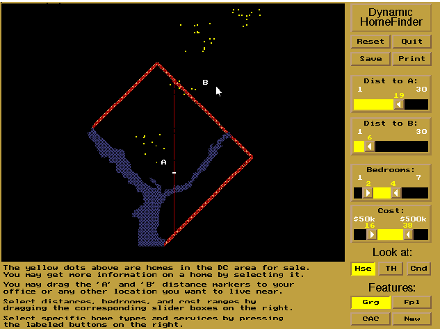
In this assignment, you will explore the issues involved in implementing interactive visualization software. Specifically we would like you to implement the interactive technique of dynamic queries – first explored in the HomeFinder application. However, instead of housing prices you will build an interactive visualizations for a dataset containing information restaurants in Santa Clara county including the Stanford Campus. Note that this data was produced by coming information from several sources including SCCDineOut, US Census batch geocoder and our own approach for synthesizing data for restaurant ratings and number of reviews. The data was created in October 2026. Please use this dataset for this assignment.
Requirements
The data includes lat/lon locations for restaurants in Santa Clara County, their address, along with other descriptive fields including the latest food caility inspection score, a placard color based on that score, a synthesized restaurant rating (based on a small amount of Yelp data from the area) and a synthesize number of restaurant reviews. You don’t need to worry about our data synthesis process. Just treat these as ratings and number of reviews as you might see on Yelp, but know that they are fictitious (we couldn’t get real data from Yelp).
Note that the data may contain multiple restaurants at the same location and null values in some of the fields including location. The dataset contains just over 9700 rows with each row corresponding to a unique restaurant. Your goal is to show each restaurant in the dataset as a data point on a map of Santa Clara county and provide additional dynamic query functionality as follows:
-
You must allow users to specify two draggable locations A (e.g. point of interest 1) and B (e.g. point of interest 2), as well as an adjustable radius for each one and filter the locations to those that lie within the intersection of the circles around A and B. (Other locations should be grayed out.) The positions of the circles should be draggable, and the two query circles can already be visible on the page upon loading. You may use either sliders or a draggable edge on the circles to adjust their radii. If you want to be fancy you may try letting users adjust the radii using either sliders or a draggable edge, but be careful, implementing both so that they update properly (i.e. the sliders update when you drag the edge and vice versa) can be somewhat tricky.
-
When the user hovers over a restaurant location point, the name of the restaurant an and other relevant fields (e.g. ratings, reviews, latest score, placard color, if these are not null) should be visible. These should not be visible otherwise.
-
You must provide at least 2 additional filtering controls that allow users to filter out specific aspects of the data (e.g. filter the addresses to keywords so that users can focus on restaurants located at Stanford or on El Camino Real, limit the placard color, limit the ratings, etc.)
The application should update at interactive rates (0.1s update rate) and part of this assignment is to write the code so that the filters operate quickly.
You can work by yourself or with a partner for this assignment. Groups of three or more are not allowed. Your group must write code for this assignment. You are free to write the code in any programming language/environment you prefer, including JavaScript, C++, Python, Java, etc. In addition you may use any software toolkit to help you build the code. However, we strongly recommend using JavaScript and D3 for this assignment. The teaching staff will provide support for coding the assignment using these tools either in Observable. We cannot guarantee that we can help you in other coding environments. We expect you to write the code from scratch, but if you use any pre-existing resources (e.g. Stack Overflow, extensively peruse related code on GitHub, chatGPT, Claude etc.) we expect you to list them as part of your submission and explain how you used them.
No matter what language/libraries you use we would like you to submit either an Observable notebook or a final executable program that we can execute on our own on either a Mac OS X or a Windows machine. Ideally, you should submit the work as a link to a website (e.g. an Observable notebook or a standalone webpage, such as one hosted through GitHub pages) where we can run your code along with the source code. If this is a problem for you, please talk to us right away.
Deliverables
Your final submission should include:
- A link to a published version of your Observable notebook or the bundled source code for your application uploaded as file (either a .zip or .tar.gz archive) to Canvas. If your code is designed to be run in a browser you must also provide a link to a live version on the web, Please ensure that the software submitted is in working order. If any special instructions are needed for building or running your software, please provide them.
- For submissions by groups of two, please also include a breakdown of how the work was split among the group members.
- We expect you to write the code from scratch, but if you use any pre-existing resources (e.g. Stack Overflow, extensively peruse related code on GitHub, chatGPT, Claude, etc.) we expect you to list them as part of your submission and explain how you used them.
- Finally, please include a commentary on the development process, including answers to the following questions: Roughly how much time did you spend developing your application? What aspects took the most time?
Upload a link to a published version of your Observable notebook with an embedded write-up, or upload the bundled code and your write-up as a PDF, to Canvas. If you’re working in a group of two, please just have one person submit to Canvas, but make sure to include both group members’ names in your write up.
Your assignment must be posted to Canvas by Monday Oct 26, 2026 by 10:30am.
Santa Clara County Restaurants Data
We have set up the Santa Clara County Restaurants dataset to contain about 9700 rows with the following fields:
Name: A string giving the name of the restaurant.Address: A string containing the address of the restaurant.Latest placard color: A string (usually red, yellow or green) correlated with the latest inspection score. See SCCDineOut for more details. Click on the blue information icon.Latest Score: A number indicating the facility’s overall compliance with inspection codes. A pefect score is 100 and points are deducted for violations. See SCCDineOut for more details. Click on the blue information icon.Distance: The distance of the restaurant from Stanford which is assumed to be at lat/lon 37.42766/-122.17006.Latitude: The latitude of the restuarant.Longitude: The longitude of the restaurant.Rating: A synthetically generated rating for the resaurant between 1 and 5.Number of reviews: A synthetically generated number of reviews for the restuarant. If a restaurant has a rating this number has to be greater than 0.
The last two fields were synthetically generated from a small set of Yelp ratings and number of reviews. As noted above the procedure doesn’t matter and you should just treat this numbers as if they are ratings and number of reviews.
Resources
Map
You can use this PNG map of the region covered in the dataset as the base for your visualization. (You are also welcome to use a different strategy for mapping, but make sure we can see geographic detail comparable to the provided map.)
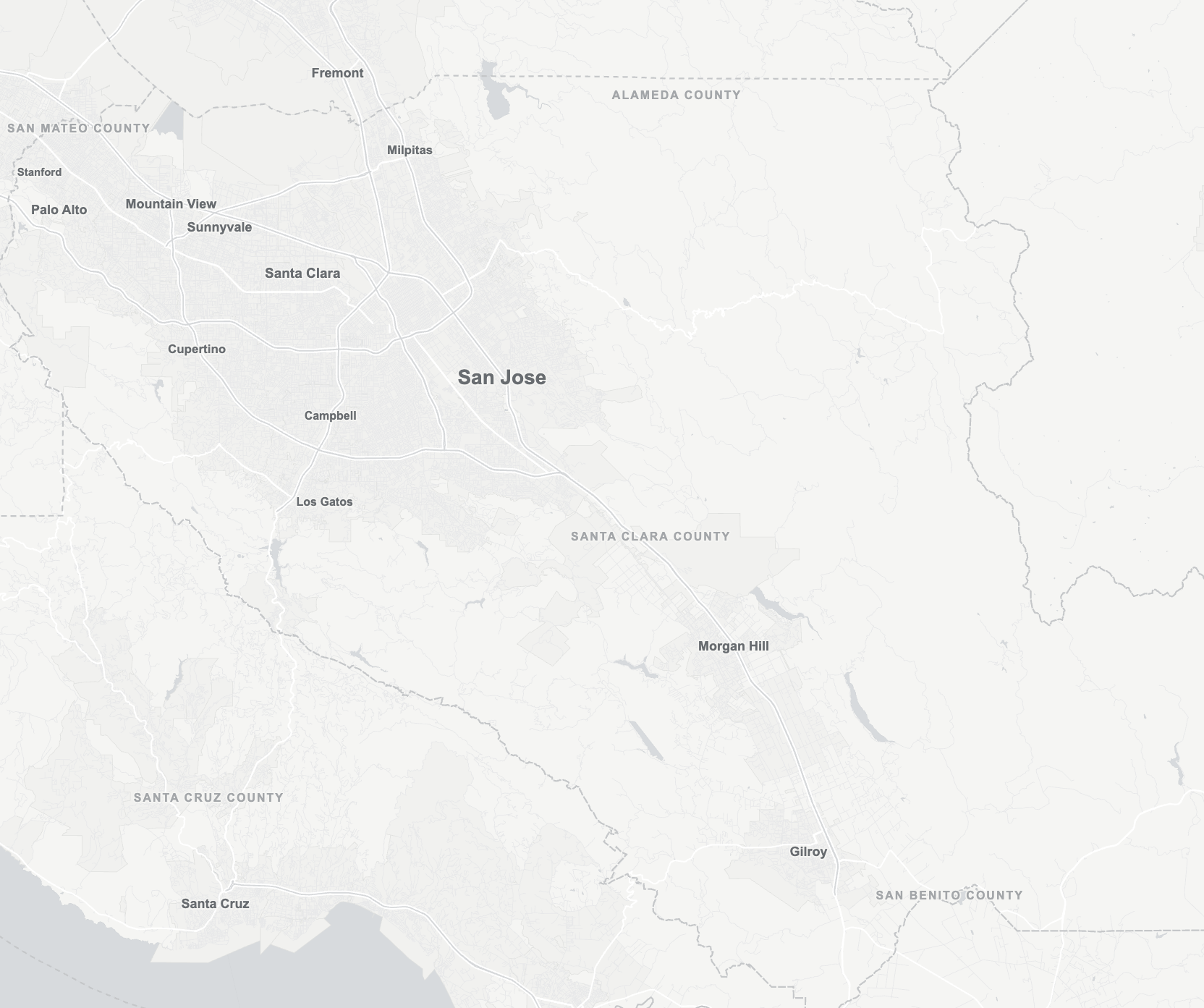
If you use the provided map, here’s a sample D3 snippet to set it up.
// Assumes you've included D3 version 7 somewhere above:
// e.g. <script src="https://d3js.org/d3.v7.min.js"></script>

const mapScale = 2;
const mapWidth = 1664 / mapScale;
const mapHeight = 1393 / mapScale;

const longitudeRange = [-122.20085766666666, -121.27442433333333];
const latitudeRange = [36.91311264279123, 37.53067882428926];

const mapFrameGeoJSON = {
  type: "Feature",
  geometry: {
    type: "LineString",
    coordinates: [
      [longitudeRange[0], latitudeRange[0]],
      [longitudeRange[1], latitudeRange[1]]
    ]
  }
};

const projection = d3.geoMercator()
  .fitExtent([[0, 0], [mapWidth, mapHeight]], mapFrameGeoJSON);

const container = d3.create("div");

const svg = container
  .append("svg")
  .attr("width", mapWidth)
  .attr("height", mapHeight)
  .style("border", "1px solid black");

svg.append("image")
  .attr("width", mapWidth)
  .attr("height", mapHeight)
  .attr(
    "href",
    "http://magrawala.github.io/cs448b-fa26/assets/a3/sccRestaurantsMap2026.png"
  );

// Example of adding one restaurant point.
const projectedLocation = projection([
  restaurant_longitude,
  restaurant_latitude
]);

svg.append("circle")
  .attr("cx", projectedLocation[0])
  .attr("cy", projectedLocation[1])
  .attr("r", 2);

container.node()
The projection function returns a mapping from the coordinates
([longitude, latitude]) to the [x, y] pixel on your static map
backdrop that matches to the longitude/latitude pair. The projection
is an instance of a D3
projection. Feel free to read the
documentation to see more information on what you can do with the
projection function.
If you have a datapoint d with a given latitude and longitude, you
can add a circle to the map in the following way:
var projectedLocation = projection([business_longitude, business_latitude]);
var circle = svg.append('circle')
  .attr('cx', projectedLocation[0])
  .attr('cy', projectedLocation[1])
  .attr('r', 1);
To load your data, you can use the following code:
const data = d3.csv(
  "CSV_FILE_URL",
  (row) => {
    // Here you can add any pre-processing to each row, if needed
    return row;
  }
)
You are welcome to fork this starter Observable notebook: https://observablehq.com/d/acffc27512286e98.
FAQ
How to respond to DOM events e.g. clicks?
Similar to jQuery, D3 provides a simple interface to add even
listeners: use the on method on any
selection. For
example, to listen to click events on circles and print out the
associated data object:
d3.selectAll('circle')
  .on('click', function(d) { console.log(d); });
Why is my data undefined?
You are most likely trying to use your data before it is
ready/loaded. In JavaScript, HTTP requests are handled
asynchronously. When you call d3.csv, the browser starts makes an
HTTP request to that resource, and it immediately continues to execute
the following code:
// In D3 v7, the csv function uses Promises instead of asynchronous callbacks to load data
d3.csv("file.csv").then(function(data) {
	console.log(data);
});

// This code is going to run before data is loaded, and you cannot use the data here
console.log('We don't have the data yet.');
nonDataRelatedStuff();

// This will print:
// => We don't have the data yet.
// => We have the data now!
How should I be doing my D3 development?
If you submit an Observable notebook link, we will be testing your visualizations by running the cells directly within the notebook itself, using the most recent stable version of Google Chrome.
If you submit bundled code, we’ll be testing your visualizations in
the most recent stable version of Google Chrome (unless you come talk
to us with a really good reason to do something differently for you),
so use Chrome to develop. Chrome’s
DevTools
can be quite helpful as you work. Chrome also supports many ES6 and
beyond features (const
and let, arrow functions, async and await, etc.) so you’re
welcome to use these if you’re familiar with them, but there’s
definitely no need.
You might also need to run a local web server while you’re developing,
because Chrome may fail to load data through d3.csv (or other
XMLHttp Requests) for security reasons if you don’t. To do this, you
can run python -m http.server from the directory where your code
lives. (Your command line should give you a localhost link.) If that
doesn’t work for you, come talk to us.
You can use GitHub Pages to host your web-based visualization software at no cost. As a student, you can upgrade your GitHub account to the Pro version for free by signing up for the Student Developer Pack. The Pro version allows you to keep private repos.
Other resources for learning D3 (and other web programming)
-
Review the slides for week 4 of the class (These have some links to other resources in them too), and other links on the homepage of the website.
-
There are lots of D3 code samples on Observable, a website run by the creator of D3, Mike Bostock. You can definitely take a look at examples here (and on Stack Overflow, etc.) for learning techniques, but please be very transparent by citing any external code snippets that you adapt, or even ones that simply inspire how you do something. We expect your design choices and your implementation to be original.
-
When in doubt, refer to the D3 API documentation. It is dense in places, but very thorough.